The alarm went off this morning while we were running Gennie. We had to get to Lois appointment so I just shut her down but when we got back to the boat I went down to look for the problem. Didn't take long to find it ... the seacock was completely plugged with the whispy green sea moss which catches on our lines every time we hang them in the water. It was plugged so tight that I had to hook up the fresh water hose and blow it out with pump pressure. Impeller seems okay though. This one has lasted several hundred hours, longer than I've ever had one last before. Wonder it they changed materials?
It was almost six before the Bergs showed up. I met them at the float plane float, brought Allyn and Hailey back to the boat, then Dick and I went to buy some dry ice. Wow, they wanted $15 per pound for the stuff! We bought one pound and decided that we'd make that do. We'll have to eat any excess fish we catch.
09:10 On our way again.
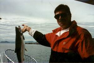
10:30 Anchored in Harlequin which I thought we'd have all to ourselves. No such luck, there's a crew of fishermen camped on top of the midden. Oh well, it's a pretty place anyway and we had a great time. We all piled in Stormy, went ashore, and walked the trail to God's Pocket. Hailey led the way following the trail markers. Had a good lunch there after poking around on the dock for a while. The water there is crystal clear and there are lots of sea anemones, starfish, kelp crabs, and other neat things. After we got back from our hike Allyn baked a cake for Lois birthday then I took Allyn and Hailey fishing on the rocks outside the cove. We got eight rockfish in a few minutes and Allyn fileted most of them. We had a nice birthday party for Lois with barbecued steaks for dinner, party balloons, and the cake lit with candles, including one which was supposed to play the Happy Birthday tune when lit. It didn't work then; but, when I squeezed it, it started playing and then wouldn't stop. Lois said it was a very Happy Birthday.
|
|
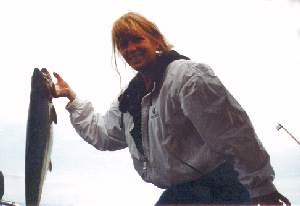
09:00 Heading out. Goin' fishin'. Wound our way out the entrance and across the channel to Davey Rock, showed Dick and Allyn the ways of using our old Peetz single action reels and poles, and got them into the water. Fished along the rocks on the south side of Wishart Island with no action so pulled in and ran down to the end of Deserters Island where several other boats were fishing. Pretty quick Dick had a couple of strikes. Then, in the channel between Deserters and Echo Island, he got a good hook on nice twelve pound Coho and brought it in. |
| About ten minutes later, on the other side of Echo, Allyn did the same thing. Dick was at about 35 feet with a red Hot Shot and a pink hoochie, Allyn was at 50 feet with a green Hot shot and a green hoochie. I think when the fish are biting they'll take anything. We fished a while longer but then, because it was noon and we were nearing low tide, we decided to run on into Blunden Harbour and dig some clams. On the way Lois and Allyn fried the rockfish we'd caught last night. Sure made a good lunch. |
|
13:00 Anchored in Blunden. Drop Stormy in the water, jump in, and run to the little bay where Larry and I found the clams. Not as low a tide today but low enough. In a half hour we had a half bucket full. On the beach just above the tide line I noticed a campfire still smoltering. Investigating, I found a pile of freshly cooked crab legs lying on the grass beneath a log. Someone had cooked several crab, eaten the bodies, and thrown the legs, including the big claws, on the grass. Well, we were there before the birds found them, so we had crab for our luncheon desert. Back at the boat, Dick and I went to work on the fish while Lois took Allyn and Hailey to the old village site to look for treasures. Got that all done, then changed Gimmy's oil. Busy afternoon. Steamed clams and fresh salmon for dinner. We're eating pretty good.
| And, a pot of crabs to cook in the morning, product of our salmon carcasses. That was the last of our productive fishing for a while though. Yesterday it seemed we could do no wrong, today we couldn't seem to find the fish. Trolled first, out in front of Blunden where Larry and I caught the six salmon. Nothing, not a bite. Decided to try for halibut on Thompson Bank. Fished for an hour there with no success. As we were pulling up we found a tiny halibut on Allyn's line but it got off the hook before I could get the net. Tried another spot for halibut, then trolled for a while ... still nothing. Finally, at the west end of Malcombe Island, near the "kelp patch", Dick started catching rockfish with the spinning pole and a Buzz Bomb. That, and more clams from last evening's dig, made our dinner. | 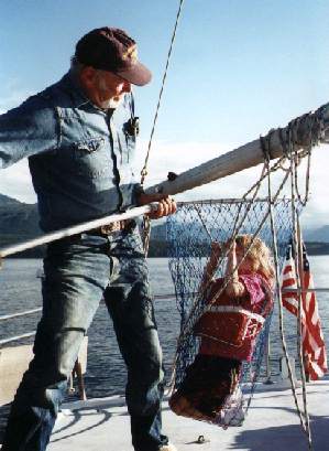
|
Not as nice a day today as it has been, light rain in the morning and hazy. No wind though, and the strait was glassy smooth all day. Cleared up in the PM as we were coming into Alert Bay. All the docks and buoys were full there so we dropped our hook in front of the downtown public dock. Then we watched some poor guy in a sailboat struggling to get his anchor back up. He finally winched up a tremendous ball of kelp. We may have the same problem in the morning.
13:20 Hauled up a nice clean anchor with no problem. Beautiful afternoon for a run up the strait. We passed gillnetters standing by in almost every little cove on the way but only a couple fishing. I guessed that the ones we saw fishing might be sampling for the authorities.
16:30 Tied to our spot on the log boom again. Constant stream of gillnetters moving out now. Must be an opening tomorrow. As soon as we got tied down Dick and Allyn went over to the parking lot to check on their car and found it gone. My goof. When I called the Seaplane Port manager, Clayton Hutchins, who had said it was okay to park there, he said I should have asked him for a permit to put in the window. Problem to work in the morning.
Back at the boat, Lois cleaned house while I changed the Racor fuel filter, did a bunch of other maintenance chores, then went to work on our windless. I've been fussing about it ever since it came apart the last time; it seems to be harder to turn than it should be. So, I took it off again and tore it completely down, taking out all the gears and shafts. I took the shaft, key, and gear which had been damaged over to the seaplane port and called Alex Prestwich, a machinist recommended by Clayton. He came down, looked at my problem, and allowed as how he could come up with a fix. He took the parts back to his shop to work on them and I went back to the boat to service the rest of the windless. I found that the main shaft that holds the gypsy and wildcat was dragging. Seems like the fiber bushing which it rides in had swelled. Not sure why, heat maybe, from being turned too fast. The windless is designed as a hand cranked unit and our hydraulics do turn it a lot faster. Anyway, I reamed out the bushing with #400 sandpaper until it turns smoothly and easily and greased it and the other gears with silicone grease. If Alex gets the other shaft fixed we'll have a like new windless tomorrow.
Ran Lois up to the laundromat this morning then came back and went to work on my windless again. On the way we passed SEABORN anchored in center channel with a gillnetter tied to each side. They had been on their way to Bella Bella when they got a call from the fish company they work for pleading with them to pack salmon here in Hardy. So they vame back, unloaded their little car, loaded up with ice, and here they are, Mary shoveling ice while Phil helps move the fish from the fishing boats to his hold. They're going to be through today so we made a date for dinner.
Alex had my shaft for me this morning as promised. It was a bigger job than he'd figured. Said he worked five hours on it but only charged me $60. He made a step key to go in the shaft, 3/8 wide in the shaft and 1/4" for the gear slot. Also made an extra key in case I should someday goof and drop one in the drink. When I tried to put everything together though, I found that the fiber bushing for this shaft also seems to have swelled. I'd have gotten it working but I had to go back to town for Lois and then the rain kept us cooped up all afternoon. There's always tomorrow.
Braved a downpour to have dinner at the Glen Lion Inn here at the Quarterdeck Marina. Not bad, but not outstanding. We'd planned on going to the North Shore which we'd been told is very good, but the rain was pouring down and the taxi company said there'd be a half hour wait. Came back and spent until midnight picking Phil and Mary's brains on west coast anchorages. They say it's their favorite cruising area. Phil marked a bunch of spots on our charts. Neat people. They have some wild tales about packing urchins on rocky shores in mid-winter storms. They are starting to think about a land base though and have bought property here in Port Hardy and on Gabriola Island.
09:25 Anchor came up smooth and easily. Windless working better than it has in years. Ran out to the entrance of the bay where a dozen or more boats were fishing and dropped in our lines. No action; and we didn't see anyone else catch a fish either.
10:35 Running again, up the Goletas Channel toward Hope Island. On and off fog as we ran, but not very thick. Fished again across the mouth of Susharti Bay with no success.
13:00 At the entrance to Bull Harbour. It was flat calm on the Nahwitti Bar and we were at high slack, perfect time to cross the bar but if we had kept going we'd have gotten to Sea Otter Cove at low tide. With one fathom in the entrance, that's not good timing for us. So, into Bull Harbour instead.
13:30 Anchored in this snug harbour with two small sailboats. One big shrimper on the government dock where the Coast Guard lifeboat used to park. Got Stormy down and went ashore. The dock is getting pretty run down now but we parked Stormy there and walked the road to the old Coast Guard station. It's a pretty walk through the muskeg forest to the north end of the bay where the buildings are. On the way we passed a beautiful little pool covered with blooming water lilies. The generator stations have been emptied but the houses seem in pretty good condition. We'd heard that an Indian carver named Simon lives here and some of the houses appear occupied but we saw not a single soul on our walk through. The roller beach on the north side of the island is as we remembered it - surf rounded rocks sorted to size by the waves, the largest high on the beach with soft sand at the bottom. No rumbling of the rocks this afternoon though; the sea was flat with barely a six inch swell coming into Roller Bay.
Back at the dock we took Stormy for a tour of the harbour. Beautiful sea caves just outside the entrance, and leaping rockfish in the kelp beds there, dozens of them flipping themselves out of the water. I've never seen anything like it. We talked with a guy on the detached float who was fishing rock cod off Cape Scott. He said they'd done pretty well and had 4000 fish in the holding pens there. He was just about to load them up and take them to market. We also talked with the guys on one of the sailboats, Pat with flaming red hair and beard, and Drew his crew. They had come from Japan and were on the way to California. Pat knew Doug and Kris, the couple on KAYAK who we met in Friday Harbor.
There are a couple of anchorages on the north end of the island that Phil told us about but with the weather forecast still for strong northwest winds we decide to skip them. Once past Cape Scott we'll be heading southeast so those winds will just push us along. On the lee shore it would be a different story.
10:30 Cape Scott. The charts and books say that there's a maximum of a three knot current in Scott Channel between the cape and Fox Island five miles to the northwest but this morning it seems to be stronger. We're at the height of the flood tide and the waves here are bigger and more confused than on Nahwitti. I drop in the other flopper=stopper foil and increase RPM. We're indicating 7.6 through the water but the GPS says we're only doing 3.2 over the ground as we slog our way around the cape. We've beat the wind though, there's hardly a breath of it to put a ripple on the water. A big Sea Lion waves at us as we round the corner.
11:30 Finally picking up a little speed again and heading southeast down the west side of the island. Waves on our quarter now and the ride is easy. Still happy to have the F/P's though, every once in a while a big swell from the west tries to tip us over. As we approach Sea Otter Cove some kind of animal waves a triangularly shaped fin at us. At first I thought it was another Sea Lion but it didn't look right. We never saw a head or body, just a light colored something under the surface and this foot high fin waving at us as we passed. We saw three of them in the distance of a couple of miles.
|
There's a big barge anchored in the cove with a motorhome, truck, crane, and a bunch of junk on it. Looks like it might have something to do with logging. Only appears to have one guy on it. He rowed to shore in a ding and disappeared for a couple of hours before coming back. Almost at dark a fishing boat came in and took a buoy near us. It's sure not crowded here as the books would have you believe.
On the way back from my exploring I stopped by and talked to the young man on the barge. He's with a salvage crew, right now caretaking the barge while the rest are off working a mechanical problem. He said they were in the process of recovering a load of "steel grinding balls" which had gone down off Cape Scott. In our conversation he cleared up the question I had from yesterday ... the strange fins we saw waving at us belonged to Ocean Sunfish. He said they are common in this area. Looking them up in the book later, I found that they grow as big as nine feet long and can weigh a ton. They lie on the surface and wave one of their pectoral fins in the air. We saw three more on the way down to Quatsino Sound today.
12:00 Charley saying, "Fifteen", and we've got enough water to be comfortable leaving so we cast off the buoy. Never had less than forteen feet on the way out to the entrance. Once outside I dropped one of our flopper-stoppers in the water and today that was all we needed. The winds that the weather people have been predicting still haven't materialized and the only seas we had were the big pacific swell which was running about six feet today. The west coast of Vancouver Island is much like that of the Charlottes, rugged in places but with many breaks in the steep, rocky shores. In it's 250 mile length there are five major sounds plus two large inlets and dozens of other nooks and crannies which our books describe. We'd never be able to explore them all in the time we have this summer. Today we passed over San Joseph Bay, Raft Cove, and Grant Bay on the way to Quatsino Sound. Stopped and trolled for a while when we saw reflections on the sounder but got no action.
15:30 Around Kains Island and the Quatsino lighthouse and into the sound. Quite a number of commercial fishing boats working in and just outside the entrance, and we saw one small sailing vessel heading south. Heading up Forward Inlet toward Winter harbor there was a steady stream of fishing boats and it was obvious that that would be a busy place tonight so we opted instead to pick up a buoy on the north shore of Mathews Island. We can spend a quiet evening here and go to the big city tomorrow morning. One other boat here, the MARY ANNE, a Tollycraft of about 40 feet with a big Whaler full of dive tanks in tow.
09:10 Parked on the fuel dock in this neat little fishing village. Bought one pail of Chevron Delo 100 #40 from the friendly attendant and traded another #30 (all they had in Port Hardy) for #40, filled Stormy's tank with gasoline, and our water tank with water. Next door the BC Packers docks were almost empty of fishing boats ... they're all out fishing ... so we moved over there while taking a walk through the village. Winter Harbour is aptly described by our books as "quaint". It reminds me very much of Tenakee Springs in Alaska. No hot springs, but a long row of neat houses set along a boardwalk rimming the edge of the bay, one general store, a B&B, and two or three fish processing operations. We walked the boardwalk to the phones in front of the one room post office and called Dad and Nan. Found that Howard and Judy have run into a problem and won't be joining us this week. Too bad. We were looking forward to their visit. Maybe later. Walked to the end of the boardwalk, at least a half mile, and then climbed up to the gravel road and followed it back. On the way we stopped to talk to a couple shoveling gravel at the side of the road, Bob (Frosty) and Liz Frost. They have just started a fishing charter business here and know the Seaborns. They gave us some helpful advice on where and how to catch halibut and salmon. The store is very well stocked with fishing supplies and groceries but we didn't need much. I bought Lois a fancy T-shirt.
11:35 Off the dock again for a look at Quatsino Sound. With our good guide books and Phil and Mary's advice we are well armed with info on places to see, so we made this day a survey trip. Swung past Nordstrom Cove (Could be a pretty place to park) and Mabbot Island (Too open for our tastes and has a big fish farm). Poked our nose into the anchorage behind the Koskimo Islands (Looks pretty good). Nothing interesting we could see in Koprino Harbour. Around Drake Island we found several neat places: Julian Cove I'd rate #1, Pamphlet Cove #2, and Smith #3 based on just a swing through..
15:45 Hung our hook in Pamphlet Cove because it was Phil and Mary's Number 1 choice. They told us there is a trail across the island to a homestead on the other side. We didn't take it this evening though, we went fishing in Stormy instead. At first we tried jigging off the kelp beds at the mouth of the cove. That didn't work so Lois suggested trolling. In five minutes we had three nice little rockfish. Then her reel got all messed up so we quit. It was plenty of fish for Lois super fish tacos though. Um, good! And we caught one keeper crab with the carcasses of the rockfish. We're doing alright.
10:15 Pulled a muddy chain and anchor from the bottom and ran across the inlet to the government dock at Bergh Cove where a young man and his son helped us squeeze onto the float. Paul is a prawn fisherman ... we'd been seeing his floats ... living in a small houseboat and fishing this part of the sound. Jordy, his son, is with him for the summer. They said they normally anchor in Julian Cove but are here in Bergh to do some engine work on the houseboat. Nice guys, they came aboard for a tour of the SEA RAVEN and briefed us on the community of Quatsino here in the cove. They said there are about thirty permanent residents here, a school which seven kids attend, and Saint Olaf's Church. The nearest store is in Coal Harbor about six miles away by water. We walked the logging road from the docks for a half mile, stopping to sign the guest book at St. Olaf's. It's a very pretty little frame building with wooden pews, an electric organ near the pulpit, an old foot pumped one in the vestibule, and a sign outside the entrance saying "Established 1876". There are some very nice homes along the waterfront, some beautifully landscaped.
11:30 On our way again. Paul had said that there were salmon to be caught right out in front of the village so we started trolling as soon as we got in deep water, sort of drifting along with the incoming tide. Before long Lois and one on. She pulled in a nice little five pound Coho. I caught nothing but weeds.
12:00 Stopped fishing and ran through the Quatsino Narrows to Coal Harbour. The narrows are fairly fast moving ... we were doing 13.5 knots in the fastest part ... but wide and straight. Today there wasn't even much of an overfall at the end. Quite a bunch of small boats fishing the edge of the swirls at the far end but we didn't stop.
13:20 Coal Harbour. Not nearly as interesting a village to us as Winter Harbour or Quatsino. It's at the end of a ten mile paved road to Port Hardy and there are lots of trailer boats running around. We walked up to the coffee shop and looked at pictures of the whaling station which closed down in 1956, the last one on the west coast. In front of Moby Dick's store are a pair of whale bones and a harpoon gun, relics of those days.
14:30 Off again, fishing back toward the narrows. No luck this time although Lois got a hit and, when she pulled in her line to check the lure, a big salmon followed it right to the surface. The fish are there alright.
15:30 Through the narrows again, fighting our way this time against a three or four knot current ... slack tide wasn't until 17:00 and we didn't feel like waiting.
16:30 Anchored in Julian Cove. Very pretty place, a landlocked bay about a quarter of a mile across surrounded by old growth forest and tucked up under some steeply rising mountain slopes just to the south. Sat in the sunshine sipping our drinks and listening to the Kingfishers scolding and the Great Blue Herons squawking while I barbecued our salmon for dinner. After dinner we pulled four nice crabs up from their feast on the salmon carcass. Great end to a perfect day.
13:30 Parked on the government float in Winter Harbour. Called Nan and found that we can get an 8-D battery in Seattle for about $140 as compared to the $190 it would cost us here so decided to wait and have she and John bring us one. So far there's only one cell out of twenty-four that isn't working so we aren't taxing the system too much (I hope!) Dropped mail at the post office, bought a head of lettuce and some booze at Grant's store, dumped our waste oil and trash, and topped off our water tank. We're all set for another leg of our trip.
15:00 Hanging on our buoy behind Mathews Island watching the fog roll in. We could see it coming out in the entrance to the sound and it rolled down the channels on both sides of our little island leaving us in the sunshine. Stayed that way until after seven; then, as the sun got lower on the horizon it lost the battle and faded away. Stuffed ourselves with crab for dinner. Another crappy day in paradise.
07:45 Breakfast over and we're on our way. Out on the ocean it was almost as calm as in the inlet. There was a little chop from the morning breeze but it fell in behind us as we cleared the Kain Island lighthouse; and the northwest swell was only two or three feet high. We ran out to a spot about two miles west of Kwakiutl Point where the bottom is flat sand and I started jigging. Frosty had told us that, if we used bait, the dogfish would never let us get to the bottom. Well, I jigged for a half hour (Lois said it was too rolly) and got nary a bite, so we moved a mile or so farther south. There, I jigged again for twenty or thirty minutes before hooking something on the bottom that wouldn't let go. It wasn't a fish and after several minutes of trying to get it free my line broke and I lost my expensive Norwegian jig. Damned halibut sure have cost us more per pound caught than Salmon and Rockfish.
11:00 Gave up fishing and headed in to the Klaskino anchorage. Klaskino Inlet is in the far northwest corner of Brooks Bay and the anchorage is just south of the mouth behind an island called appropriately Anchorage Island. It's kind of spooky getting in there, the whole end of the bay is dotted with rocks and little islets beaten by the pounding surf. But today the surf wasn't pounding very hard and we were at low tide so most of the rocks were visible. We came through the Newton Entrance, around Rugged Island, which has a light on it, and then between the two buoys marking the channel. No problem finding our way into the anchorage where there are three public mooring buoys. It is flat calm in here tucked behind the reefs and islands with the remarkable mountain called Yaky Kop Cone looking down on us. Spent the rest of the day enjoying the sunshine and exploring the area. The books say this and Klaskish just to the south were the most southerly strongholds of the Kwakiutl people. This must have been an ideal location. There are two large streams coming into the bay on the south and east, each pushing a drying flat out into the bay. Near the east stream is a large, flat, forested point fronted by a soft sand beach which would have been ideal as a village site. We couldn't find any sign of it but the rain forest here soon covers manmade things. There are lots of large clam shells which our books says are Alaskan Surf Clams lying on the shores but today's low tide wasn't low enough to uncover any beds. Over in the bay behind the next island we found an old fisherman anchored. He said he is fishing cod for a Chinese market in Vancouver. He keeps the fish alive in a tank on his boat then offloads them to a tanker truck in Winter Harbour for shipment to Vancouver. Says he gets a very good price for live fish there.
08:00 Off our buoy after a lazy breakfast. The recorded weather report on the radio said that Solander Island was reporting 17 knot winds at 04:00 AM but it was flat calm as we made our way around Anchorage Island and northwest behind the Steel Reef. I opted to go out the way we came in, through the Newton Entrance, even though it is about ten miles farther than taking a shortcut through the reef. We weren't planning on going far today and I had thoughts of trying again for halibut, this time out in Brooks Bay. We cleared the reef buoys and had rounded Rugged Island and taken a heading back southeast across the bay when I noticed the clouds now boiling over the Brooks Peninsula and around Solander Island. Ten minutes later the first ripples came sweeping toward us from the south. Another ten and the anemometer was reading 25 knots and we could see whitecaps coming toward us from the southeast. Fortunately, we only had six miles to go to Klaskish Inlet at the southeast corner of the bay because in ten more it was reading a steady gale force 35 with higher gusts and every wave was getting bigger. There was no rain but wind blown water was covering the windshield faster than the wipers could take it off. No halibut fishing in Brooks Bay today.
10:30 Close now to McDougal Island and the entrance to Klaskish Inlet. Wind still howling but now it's got no fetch and the waves are nothing more than a one foot chop on the surface as we navigate the inlet up to the Klaskish Basin entrance. The books say that the entrance is so narrow that the fishing boats have to raise their poles to go through but I don't really believe that until we're right at the mouth of the channel. The radar, set on its minimum range, can't resolve the hole in the wall. Well, maybe we'd better get our poles in. A quarter mile long, forty feet deep and only sixty feet wide at its narrowest point, this passage is one of the narrowest we've ever been in. Sure pretty though. Vertical rock walls topped with rain forest opening up into a two mile long, half mile wide basin with a river flowing in the far end.
11:00 Tied to one of the eight Oceans and Fisheries mooring buoys here in the basin. Raining a little now, not much, just a sprinkle. Got down the ding and took a tour of the bay. The books say there is a lot of wildlife here but we didn't see much of it today. Eagles, as always, soaring above and in the trees along the shore, but no deer, bear, or wolves. Big jellyfish in the water, bright yellow guys with clear tentacles, got all over my fishing line and lure when I tried to catch some crab bait. Later I ran back out the entrance in Stormy and across to the anchorage behind McDougal Island where there are three more mooring buoys. There is the site of a former Kwakiutl village and, according to a sign on the beach, the boundry of the Brooks Peninsula Recreation Reserve. The Kwakiutls sure picked some pretty spots for their camps and villages. This one is by a pretty stream and fronted with a soft sand beach. The understory of the forest behind the beach where the village must have been is clear of brush and carpeted with a deep layer of moss and needles from the towering trees. The beach is clear of driftwood testifying that almost no surf gets to it.
No luck on fishing. I couldn't even jig up a rockfish for bait. 'Spose that big Sea Lion who watched me while I was jigging beat me to them? Seems to be a great lack of kelp beds in here. Wonder why? We ate the last of our crab for dinner and are down to one meal of salmon left in the freezer. We're going to have to do some serious fishing one of these days. On the way back from the outer anchorage I peeked into a tiny cove just outside the entrance to the basin. Two private mooring buoys there and deep in the end of the cove, on a grassy bank above a tiny gravel beach, there is a weight lifting bench and a full set of barbells. No other sign of habitation that I could see from the water. Stange! A fugitive from Muscle Beach in Venice, California maybe?
07:40 Clerke Reef. Water's glassy smooth and the clouds still hanging over the mountains of the Brooks Peninsula aren't boiling this morning. Backlit by the sun, they make a glorious crown for the rugged peaks. This peninsula, like the Charlottes, was bypassed by the last ice age and the mountains show the difference. They look more like those of the Central California coast.
08:30 Solander Island. Here, where all our literature warns of the nasty weather, it is still calm and there are a billion birds on the water, diving and screeching. The sounder is blanked out by the feed in the water. A commercial fishing boat is trolling nearby so we stop and drop in the trolling gear. Not much luck. I got the only hit and pulled in a nice little Balck Sea Bass. Oh well, it's dinner.
09:55 Running again, we pass a head sticking up out of the water watching us go by. At first I thought it was a Sea Lion but it seemed too small. I think now we saw our first Sea Otter. They were planted here a few years ago and now the fishermen say they are becoming a nuisance, gobbling up huge quantities of urchins, clams, and oysters.
10:45 Tied to a buoy in Columbia Cove after putting behind us another of the infamous capes ot the Pacific coast. This is another really neat place. We're tucked in behind a tiny island where Captain Cook battled the Indians just before the voyage to Hawaii when he was killed. We dropped Stormy in the water and went exploring. In the entrance there is an old Coast Guard cutter beached which one of our books surmises is evidence of a bad business venture. Just to the south is a large, drying, sandy flat from which our books say a trail leads across a forested neck of land to a long sand beach. We aren't all to ourselves here. There are three kayaks parked in a tiny cove near the entrance and as we were exploring a skiff with seven people and a couple of canoes on board came in. They parked as far up the flat as they could get and headed off up the beach, presumably for the trail. Looked like a guided expedition from somewhere. Later, while we were having lunch, another kayak came by the boat with a young couple from Tacoma, Les and Diane Ulrich, paddling. They are camped near the Acous Peninsula and told us about a totem and burial canoe there.
The sun was bright and warm so Lois sunned herself on the deck while I went exploring on the little island. Found a gaff hook that had been tossed up on the rocks by a big wave. Later, when the tide started to come in, we took the ding to the flat and found the trail to the beach. Cougar tracks in the sand as we walked to the trailhead where we found about a half mile of up and down, sometimes muddy, primative trail through the rain forest to the beach which today looked like one in Costa Rica or Mexico - a beautiful, curving, soft sand crescent, stretching for a mile along the shore, the sun shining through blue-green waves with white crowns breaking gently from a blue, blue sea. What a day, what a place.
08:45 Cast off our buoys after a lazy breakfast. They are a little close together in here, and the shore, so yesterday we tied a stern line to another of the three. That also allowed us to drop the crab ring over the rail and have it stay put. Not that that did us any good ... we must have pulled up fifty crabs during the afternoon and not a one was legal size. Anyway, this morning we're off to our next destination, a place Don Douglass' book calls Baidarka Cove. It's only two miles north of here in Nasparti Inlet and not named on the chart but it's the closest anchorage to Johnson Lagoon.
09:30 Anchored in Baidarka. Just as Douglass says, this is a fine anchorage. We're in sixty feet on a bottom that grabbed our anchor and wouldn't let it move an inch. We jumped in Stormy and headed for the lagoon entrance. Johnson Lagoon is about three miles long and a half mile wide with an entrance only about twenty feet wide. On spring tides they say the tidal falls is worth seeing but this week we're in very low range tides. The chart says slack occurs two hours past the high which would be at 10:30 and now, at 9:45, we ride a nice little stream through a hole in the forest wall, past a couple of big rocks, and into a beautiful basin surrounded by mountain peaks. We slowly motored the entire length of the lagoon on the sunny side, stopping once to explore a big flat where the largest stream enters. It's amazing how the streams along the shore have pushed big piles of gravel out into this deep inlet. The spring runoffs on this island must be tremendous. The only signs of human habitation in the lagoon are the remains of logging endeavors and one sunken float which looked like it might have had something to do with fishing. Back at the entrance the tide has turned right on schedule and we ride the stream out just as nicely as we rode it in.
12:30 Back on the boat, lunch over, and hauling anchor again, this time to try a little fishing in Nasparti Inlet. We idled our way out of the cove and as soon as we got into more than a hundred feet of water started letting out our lines. I was using the downrigger and had just dropped my lure down to 100 feet and Lois was still letting hers out when a fish hit my line. Nice ten or twelve pound Chinook, or Spring as they call them here. About ten minutes later I had another, this time smaller, a nice baking size fish. In another twenty, when in shallower water where my lure was closer to the bottom, a nice Yelloweye took my hook. Lois never got a hit. Funny how that happens. She's been the one catching the most fish.
14:00 Gave up fishing and went poking our way through the rocks and reefs to look at another unnamed cove that looks good on the chart. On the west side of the Acous Peninsula opposite Battle Bay, it looks to me like it would be easier to enter and just as good. It would be hard for the books to cover all the potential anchorages in this boaters paradise.
14:30 Anchored in a neat little bay tucked behind a dozen reefs with several small islets and sloping sand beaches on the shore. A loon's call welcomed us to the harbour. The chart shows that the hill to our west called Byer's Cone is a Checkleset Indian reservation. This is also the area where our kayaking friends told us there is a standing totem and the burial canoe. We cleaned and stowed our fish then took Stormy for a survey tour. What an amazing place. In this rock infested area of the seacoast are hundreds of islets and reefs which today almost completely break up the surf and swell of the big pacific. You can sure see why it was the home of canoe people, and why it is a kayaker's paradise today. We followed the shore of the peninsula all the way around to Battle Bay in flat water, sometimes having to dodge an underwater rock even in the ding. No sign of people anywhere on the peninsula but over in the west arm of Battle Bay there was a sailboat anchored. We motored past but no one was aboard. In the east arm we were surprised to find lots of people, a dozen or more in two big kayak camps, one on each side of the bay. Later I noticed that they are shown on one of Douglass' sketches as "Kayak Landings". They must fly people in to these base camps and take them o tours from here. We're happy to stay on our side of the isthmus. Tomorrow we'll go exploring from there.
The beach itself was facinating. It curves around the head of the bay behind an islet which leaves only a narrow channel on each end so it's totally protected from the surf. It must have been a great canoe landing place. The bottom is flat and must be filled with clams. Along the beach are pile after pile of clam shells, some predator's dinner leavings. Unfortunately, our tides right now aren't low enough to expose the beds.
|
Next, we took a lunch with us and went to explore the islets and shores of the south and east sides of the peninsula where the village was. Even though the wind was still blowing we had no trouble staying in calm water, protected by the rocks and reefs as we poked around the Cuttle Islets and out to the burial island that our kayaker friend had told us about. |
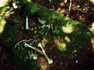
| Landing on the sandy shore of that island, we walked just a few feet into the trees to find an ancient canoe, almost rotted away, with three moss covered human skulls and a pile of bones sitting on top of it, probably found and placed there by some kayaker with a weird sense of humor. This is an Indian Reservation island but so far we've seen no sign of the "First Nation" people. I took a bunch of pictures of the canoe and island. | 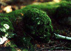
|
Going on with our exploring we went on around to Battle Bay and talked to the people on the sailboat we'd seen yesterday, Ben and Heide on the boat MANAIA from Victoria. They've been here several days, and on the west side of the island since June. We ate our lunch on the Battle Bay beach opposite the one we were on this morning. No sign of a trail through from that side either.
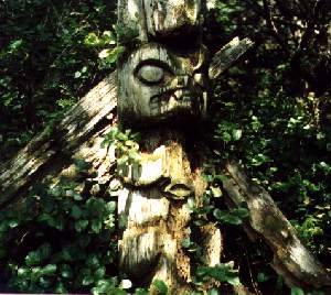
| Back at the village site we hunted for quite a while for the standing
totem before finding it almost where we'd started looking. It's a very
nicely carved mortuary pole about fifteen feet high looking out over the
reefs to the south. Nearby is a huge clamshell and ash midden, overgrown
now by the forest, and behind, the remains of at least one longhouse. Must
have been a busy place at one time.
As we left the village we talked to a group of kayakers making a lunch stop in the next little cove. They told us they were from one of the two kayak tour groups camped in Battle Bay for the summer. Gave us some good info on getting to and from Fair Harbour where I think we'll meet Nan and John. |
|
In the afternoon on the way back to the boat he wind had really picked up but with the protection of the reefs we got back without getting too wet. As we came around the last turn there was a Sea Otter lying on its back sunning itself in the lee of a rock. It watched us approach to within about fifty feet before rolling over and disappearing. Wind died down in the evening, Weatherman says it will turn around to the southeast tomorrow with a chance of showers. We'll see.